Master Plan
Nambiar Kannamangala Master Plan — Twelve Acres, Four Blocks, 71 Homes Per Acre
The Nambiar Kannamangala master plan places four Ground+20 blocks on a twelve-acre parcel fronting Whitefield–Hoskote Road at Khajisonnenahalli, with roughly a fifth to a quarter of the site under building footprint and three-quarters or more released to landscape, circulation, amenity and below-ground infrastructure. Around 850 apartments are distributed across the four blocks. From a planning angle, Nikoo Homes 8 keeps the reference local: internal roads, open-space placement, amenity access, and tower orientation all affect how the address will live after handover.
12
Acres
4
Blocks · G+20
~850
Apartments
~71
Homes / Acre
Site Plan
Nambiar Kannamangala site plan
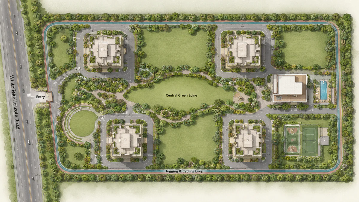
Master Plan
The controlling number: 71 homes per acre
Every other decision in this master plan follows from one ratio. Twelve acres carrying 850 homes is roughly 71 apartments per acre.
For a Ground+20 scheme that is low. Comparable East Bengaluru high-rise launches run 100 to 130 homes per acre, and the large township schemes in this belt run higher again. The consequence is not abstract:
- Tower coverage falls to roughly 20–25% of the site. Three-quarters or more of twelve acres is available for something other than building.
- Inter-block setbacks can be generous. Four towers spread over twelve acres do not need to be packed against each other, so privacy and sightlines survive from the middle floors upward.
- The landscape is a system, not a residue. At this coverage the open space is a designed, connected network rather than the leftover strips between kerbs and buildings.
- Shared resources are less contended. Pool queues, clubhouse bookings, visitor parking, lift load — all of them scale with households per acre.
This is Nambiar Builders' documented planning signature rather than a one-off. Across Bellezea, Ellegenza and the 100-acre District 25 township, the company has consistently preserved open space rather than maximising saleable area.
Master Plan
Land use
| Element | Indicative allocation |
|---|---|
| Total site | 12 acres (~522,720 sq ft) |
| Tower footprint | ~20 – 25% |
| Landscape and open space | ~50 – 55% |
| Internal roads, drop-offs and hard circulation | ~10 – 13% |
| Clubhouse and amenity built form | ~5 – 8% |
| Utilities, STP, transformer yard, service access | ~3 – 5% |
Master Plan
Building placement
Four blocks on twelve acres is a comfortable ratio, and it gives the planner freedom that a tight site never has.
The blocks are arranged around a central landscaped spine rather than in a row along the road frontage. Three consequences follow. No block looks directly into another at close range. Every block has direct pedestrian access to the central green and to the clubhouse without crossing a vehicular road. And the arrangement allows the majority of floor plates to take a north–south orientation, which in Bengaluru's climate is the difference between a west-facing living room that is unusable from three to six in the afternoon and one that is not.
The Whitefield–Hoskote Road frontage carries the arrival sequence: a set-back entry court, a gatehouse with boom barriers, and a covered drop-off at the primary lobby. Given the peak traffic this road carries between Kannamangala and Hope Farm, the set-back is a working requirement rather than a flourish — it gives arriving vehicles somewhere to queue that is not the carriageway. Service and waste access is separated onto its own approach so that refuse and delivery vehicles never share the resident arrival route.
Ground+20 is the height decision. Twenty-one habitable levels gives genuine elevation across a corridor that is still largely low-rise: upper floors will look south-west toward the Whitefield skyline and east over open land toward Hoskote. It stops short of the 27-to-30-storey heights used by the large township schemes in this same belt, which keeps vertical transport, water and air pressurisation, common-area maintenance and evacuation in a more manageable range.
Across four blocks and twenty-one levels, 850 homes works out to roughly ten apartments per floor plate. That is mid-range for Bengaluru — solid, but the site density rather than the plate count is where this project's advantage sits, and it is worth saying so plainly.
Master Plan
Green belt and open space
Half the site or more is landscape, organised as a connected system.
The central green spine is the organising element: a continuous landscaped corridor running between the four blocks and terminating at the clubhouse, carrying the main pedestrian route under tree canopy. On a twelve-acre site that spine has real length — it functions as a park rather than a garden path.
Around it sit the differentiated zones: an open event lawn sized for a community gathering, themed pocket gardens, a children's play area with soft-fall surfacing and a separate toddlers' zone, a senior citizens' seating court placed away from the play noise and near a block entrance, a reflexology path, an amphitheatre stepped into a level change, and a pet-friendly zone at the site edge.
The perimeter jogging and cycling loop runs the boundary. Twelve acres gives a circuit of genuine length — long enough for a real run, and long enough that a cycling loop is worth having rather than tokenistic.
Planting is layered: specimen trees for canopy along the spine and the loop, flowering and ornamental species around the amenity zones, screening planting along the service edge and the transformer yard, and lawn and ground cover at the base. On a site with this much open area, the tree canopy is the single largest determinant of how it feels in April.
Master Plan
Roads and circulation
The circulation strategy is vehicles down early, pedestrians above.
A single controlled vehicular entry from Whitefield–Hoskote Road passes the gatehouse and drops almost immediately to the basement parking levels, so resident traffic does not circulate across the site at grade. What remains above ground is a peripheral fire-tender and service road at the mandated width and turning radii, the covered drop-offs at each block lobby, and visitor parking bays near the entry.
The interior — the spine, the lawns, the play areas, the amenity frontages — is therefore pedestrian-first. On a twelve-acre site with 20–25% coverage, that pedestrian realm is large enough to be a genuine amenity rather than a circulation diagram.
Fire tender access is maintained to every block on the peripheral loop, with hardstanding at the designated points and turning circles sized to Karnataka Fire and Emergency Services requirements for a Ground+20 building.
Master Plan
Pedestrian movement and landscape design
Every block lobby connects to the central spine by a shaded walkway, laid to a continuous level wherever possible with ramped transitions rather than steps, so the site is navigable with a pram, a wheelchair or a wheeled suitcase.
Lighting is designed as a layer of the landscape rather than an afterthought: bollards along the walkways, uplighting on specimen trees, and higher-level lighting only where the loop meets the service road. On a site this size, getting the lighting right is what makes the far end of the spine usable after dark rather than ornamental.
Master Plan
Below-ground infrastructure
Basement and podium levels carry the parking allocation at a ratio appropriate to the configuration mix. With 3 and 4 BHK homes forming a substantial share of the plan, a meaningful proportion of households will hold two cars, and the allocation is planned for that rather than for a single-car assumption. EV charging provision is built into the basement layout at design stage — worth confirming on the specification sheet, because retrofitting EV capacity into a completed basement means new cabling runs, additional transformer load and fresh metering, and it is among the most expensive upgrades a residents' association can face.
Also below ground or at the service edge: the domestic and fire water tanks, the pump rooms, the transformer yard and DG enclosures, the STP, and the segregated waste handling area with the organic waste converter.
Master Plan
Sustainability infrastructure
| System | Specification |
|---|---|
| Sewage treatment plant | Sized for full occupancy, with treated water reused into landscape irrigation and toilet flushing |
| Rainwater harvesting | Across the full site catchment, with recharge structures, per BWSSB requirements |
| Power backup | DG capacity covering all common areas plus a backup allocation to every apartment |
| Solar | Common-area and landscape lighting |
| Waste management | Organic waste converter at source; segregated dry-waste handling and storage |
| EV charging | Provision built into basement parking levels |
| Lighting | LED throughout common areas |
| Water metering | Individual metering per apartment |
The STP with treated-water reuse carries disproportionate weight on a site like this. Half of twelve acres is six acres of planted landscape, and six acres of irrigation demand cannot be met from potable supply through a Bengaluru summer without either a large water bill or a dead landscape. Closing the loop — treating the community's own sewage and irrigating with the output — is what makes the master plan's green allocation sustainable in operation rather than only on the drawing.
Rainwater harvesting across the catchment does the complementary job on the input side, recharging groundwater and reducing tanker dependence through the dry months. In East Bengaluru's Whitefield–Hoskote belt that is an operational reality, not a compliance checkbox.
Master Plan
What to verify at launch
The master plan described here is drawn from the sanctioned scheme parameters — twelve acres, four blocks, Ground+20, approximately 850 units — and from Nambiar's planning conventions on comparable projects. The specific allocations, amenity positions and parking ratio are finalised in the sanctioned plan filed with the Karnataka RERA registration.
When that registration is published, three documents are worth reading before booking. The sanctioned plan confirms block positions, setbacks and the open-space allocation — and specifically whether the 20–25% coverage assumed here holds. The specification sheet confirms the parking ratio, the STP capacity in KLD and the DG allocation per apartment in kW. The common-area schedule confirms which amenities are in the handed-over scope rather than shown indicatively on a render.
Buyer Questions
Nambiar Kannamangala Master Plan — FAQ
/PR/); the sanctioned plan; the BDA approval; the encumbrance certificate; the khata; the title deed chain; and the draft sale agreement including the delay-penalty clause.Next step for Nambiar Kannamangala
Nambiar Kannamangala launches in Q4 2026. Pre-launch registrations receive the configuration and pricing sheet ahead of the public release, priority on floor and unit selection, and direct notification when the Karnataka RERA registration is published.